Projects
Old Maps, New Views
古地圖,新視界
Core Projects Development
核心計劃與發展
Commonality of Interest in Spatial Humanities
and Shared Technical Infrastructure
基於對空間人文學的共通興趣與共享的科技基礎
Geographic information and timelines provide an effective integrating and contextualizing function for cultural attributes. As cross walks for information from multiple sources and in multiple formats they create visual indexes for diverse cultural data. Spatiotemporal interfaces provide new methods of integrating primary source materials into web-based interactive and 3D visualizations. We are able to chart the extent of specific traits of cultural information via maps using GIS gazetteer style spreadsheets for collecting and curating datasets. The system is based on GIS point locations, routes, and regions linked to enriched attribute information. These are charted and visualized in dynamic maps and can be analyzed with network analysis, creating an innovative digital infrastructure for scholarly collaboration and creation of customizable visualizations. This method gives the researchers an expanse of data in layers of time across space providing new tools to advance humanistic inquiry. This in turn becomes a Web-based bulletin board for local community and scholarly knowledge exchange.
地理資訊與時間軸為文化屬性提供了有效的整合與脈絡化的功能。從多樣資源及藉由多種格式的資訊匯流,它們能為多元的文化資料創造視覺索引。時空介面提供新方法將初級的基礎資料整合,成為以網絡為基礎的互動與3D的視覺形像。透過使用地理資訊系統地名索引的展開式表格製圖來收集並研究資訊的不同組合,我們能夠將文化資訊的特性其最大的展延範圍具體化、視覺化。這個系統是基於 GIS 點位置、路線和區域的連結來豐富此文化屬性的資訊。這些都可以在地圖上標記、視覺化,並以網絡分析,而創造出創新的數位基礎結構,以供學術合作及特定需求的視覺化品項。這個方法讓研究者跨越空間的限制而擴大了資訊的層次,提供發展人文學高深探索的新方法。接著,以網路為基礎的佈告欄就可以成為在地社群與學術之間的信息與知識交流。
Our group projects are linked together for the synergies of mutual concerns in regional Spatial History. These include:
- Religious Networks
- Historical Migrations
- Recognition of Signs, Symbols, and Motifs
- Use of Old Maps
- Historical Spatiotemporal Indexing of Sites
- Comparing Physical Artifacts
- Multilingual and Historical Textual Information
- Genealogies
- Attributes and Features Analysis
- Cluster Mapping Techniques
我們的計畫以整合地域空間歷史領域共同的關切為目標,包括:
1.宗教網絡
2.歷史上的移民遷徙
3. 符號,象徵與主題認知
4.老地圖的功用
5.歷史地點的時空索引
6.文物的物質性比較
7.多語言與歷史文本資訊
8.系譜分析
9.屬性與特徵分析
10.聚落地圖化技術
The basis of our projects depends on “GIS Outreach” supported by our key team member Jihn-Fa Jan, Department of Land Economics, National Chengchi University. His work focuses on Integrated Geospatial Techniques for Local Community-Based Volunteer Research: A Method for Digital Humanities and Natural Resources Investigation.
我們的計畫基礎是 “GIS 推廣”,由政大地政系詹進發教授提供。詹教授的工作主要是以在地社群自發研究為基礎的地理間資訊整合技術: 數位人文與自然資源研究方法。
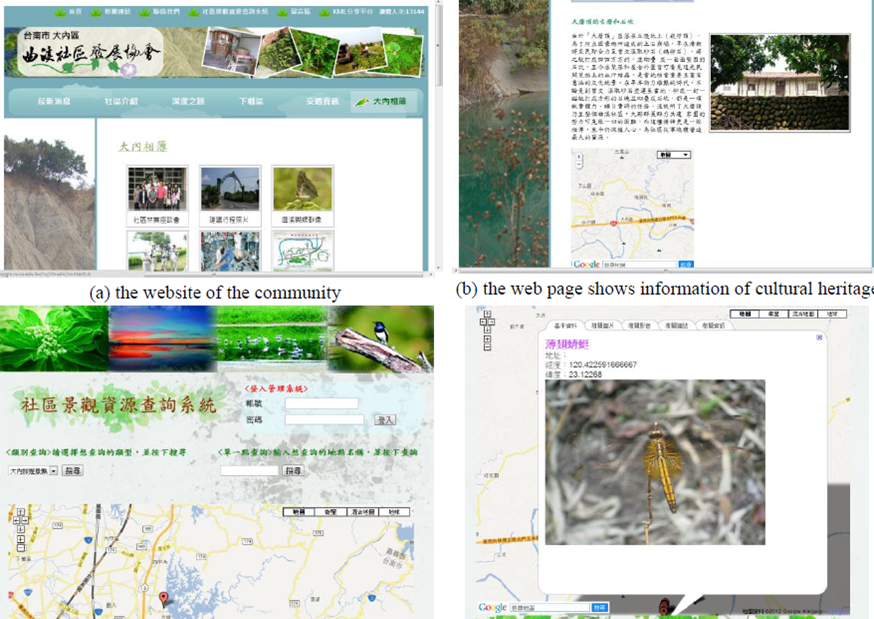
This provides an integrated WebGIS (web-based GIS), GPS, and location based service for community-based resource investigation. Major achievements in the project methodologies include: (1) utilizing hand-held mobile devices and GPS trackers for collecting spatiotemporal data; (2) constructing a GIS geospatial database to integrate data from different sources and volunteered geographic information; (3) using Google Maps/Openlayers API and JavaScript to design a website that provides embedded digital maps in dynamic web pages; (4) using open source web development tools to build a website that facilitate database management and data dissemination. By integrating Geospatial Techniques, this study aims to promote more public participation in resource conservation of a local community.
我們的計畫提供整合的網頁GIS (網頁介面GIS),GPS與社群資源探究的定點服務。計畫方法的主要成就包括: (1) 利用手機等掌上型設備與GPS追蹤器蒐集時間空間資訊 (2)建構GIS地理空間資料庫,以整合不同來源的資訊與自發性研究的地理資訊 (3)用Google地圖/Openlayers API與JavaScript設計網站,於動態網頁提供數位地圖 (4)使用資源公開的網頁發展工具建立網站,促進資料庫管理與資訊傳播。藉由整合“空間技術”,本研究以推廣公共參與在地社群資源維護為目標。
It is an opportune time, since the President at National Chengchi University, Wu Se-hwa, before becoming Minister of Education, awarded Prof David Blundell with the Top University Project in Digital Humanities.
吳思華前校長(現任教育部長)頒布授予卜道(David Blundell)教授頂尖大學數位人文計畫。
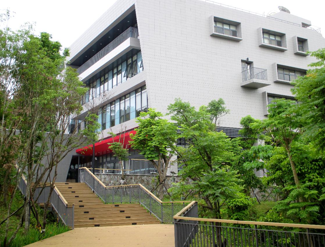
A resulting fund is available for the establishment of the Asia-Pacific SpatioTemporal Institute at the Research and Innovation-Incubation Center at National Chengchi University. This Institute will provide a space for the researchers to work and share as they conduct their Spatial Humanities research. Grad students and Post-docs versed in GIS Research and Web Development and Updating are being employed. Our guiding consultant is Jeanette Zerneke, Technical Director of the Electronic Cultural Atlas Initiative (ECAI) www.ecia.org, School of Information, University of California, Berkeley.
以此經費我們成立了亞太時空資訊研究室(ApSTi),研究室位於政大研究暨創新育成總中心。中心將提供空間供空間人文研究者工作與分享交流,並聘請研究GIS與網頁發展的研究生與博士後研究者。我們的指導顧問是Jeanette Zerneke (加州大學柏克萊分校“電子文化地圖集”(ECAI)技術主任)。
The new Research and Innovation-Incubation Center is a five story building in a forested area along the Circle Drive of the Campus. It commences operations in the Spring Semester of 2015. We will have a space opening onto a public terrace. The spatial arrangement is for IT people and Social Scientists and Researchers in the Humanities to develop new ways of viewing data. Glass walls and open public spaces invite conversations and idea exchanges for innovative research development.
新成立的政大研究暨創新育成總中心位於山上校區的森林區,是一棟五層樓建築,自2015年春季起開始運作。這裡我們將會有公共露台。空間規劃是為了讓資訊技術人員與社會科學家與人文研究者能以新的方式檢視資訊。玻璃牆與室外公共空間可以增進關於創新研究發展的對話與意見交流。
Projects:
- Austronesian Navigation and Maritime Buddhism
- Dynamic Atlas, 17th century Dutch Texts, Formosa
- Economic Cluster Mapping of Taiwan Industries
- GIS Tombs Mapping of Taiwan and Region
- Religious Networks Mapping
- Resources Management and GIS Volunteerism
- Taiwan Indigenous Innovation Arts
計畫:
*亞太南島海域航行與佛教海上發展
*17世紀荷蘭福爾摩莎文獻,動態地圖
*台灣與區域墓誌銘地圖GIS化
*宗教網路地圖
*資源管理與GIS
Austronesian Navigation and Maritime Buddhism
南島民族航海與海上佛教
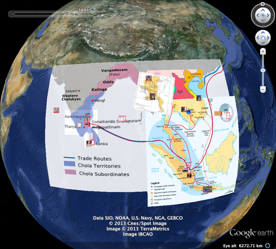
With this project we are working collaboratively to bring together data from disparate disciplines and integrate the history of the influence of Maritime activity on the development of the major religions and cultures of Monsoon Asia. Archaeological, visual, scientific and textual evidence will be contextualized by time and place providing the opportunity to study a large amount of new and vital material in an integrated manner. This will inspire scholars to ask new questions, develop new analysis using readily available new technologies, and develop nuanced interpretations of our past. In addition, the materials will be incorporated into visualization technologies to allow development of new representations and narratives enabling a wide range of users to interact with and re-envision their history.
經由這個計畫我們合作,彙集不同領域的資訊,整合海洋活動史對季風亞洲主要宗教和文化發展的影響。經由時空脈絡化,人類學,視覺,科學和文本證據提供了整合研究大量重要新材料的機會,啟發學者提出新問題,以現有的新科技,以發展新的分析與細緻地詮釋過去。此外,這些材料將納入視覺科技,使其能發展新的再現與敘事,讓大量使用者能展望他們的歷史,與之互動。
Dynamic Atlas, 17th century Dutch Texts, Formosa
動態地圖: 十七世紀荷蘭福爾摩沙文獻
As observed by Nachum Dershowitz, “written text is an ideal source for understanding life in the historical past. Manuscripts, including community documents, personal letters, and commercial records all contribute to a fuller understanding of a given time and place.” This project suggests a combination of applying digital software programs to historical materials of 17th century Dutch Formosa with specific reference to Kercboek, Brievenboek van Formosa, 23 januari 1642- 4 maart 1660 .
一如納衡德修維茲所觀察,「書寫文本是理解過去生活史的理想資源。手稿(如社群文獻,個人書信,貿易紀錄)皆使我們更全面理解該特定時期與空間。」此計畫應用數位軟體程式於十七世紀荷蘭福爾摩沙史料,尤其是福爾摩沙信函譜,大員宗教會書》 (1642年1月23日到1660年3月4日)。
The purpose of a digitalized content format envisions two larger objectives: (1) mapping the key figures in the Dutch community, their social networks and mobility in Formosa and other VOC (Vereenigde East India Compagnie) factories and (2) provide guidance and develop standards that can be applied to other digital archives and databases pondering the possibility of generalizable methods.
數位化內容格式有兩項展望: (1)在地圖上標記荷蘭社群重要人物其在福爾摩沙的社會網絡與流動性,與其他荷蘭聯合東印度公司工廠 (2)提供指導,發展可應用於其他數位檔案庫及資料庫的準則,思考通則的可能性。
The rationale behind this project is thus to develop tools that can be used to extract and visualize patterns of mobility in the VOC by its personnel that at one point had been employed in Formosa. This topic has not received the necessary attention and requires to be studied in view of the significance attached to the Tayuoan factory. Through network analyses of the names mentioned in the mission document Kercboek, Brievenboek van Formosa, it is possible to develop a set of methods that allow us to examine these questions on mobility regarding its horizontal, vertical, upward and downward specificity. The upgrade to include the methodology of digital humanities is essential in coming towards a fuller picture that contextualizes historical materials and has the capacity to change the way historians and cultural studies scholars look at mobility, past and present.
此計畫背後的基本原理是藉此發展工具,用以萃選與視覺化荷蘭聯合東印度公司福爾摩莎地區的人員的流動性模式。此主題尚未受到必要的注意,需以大員工廠的重要性加以研究。經由網絡分析《福爾摩沙信函譜,大員宗教會書》中的人名,應可發展出一套方法,供我們檢驗這些流動性的問題各方面的特性。此一重要進步涵蓋了數位人文方法,邁向更全面的史料脈絡呈現,能夠改變歷史學家與文化研究學者對過去與現在流動性的檢視。
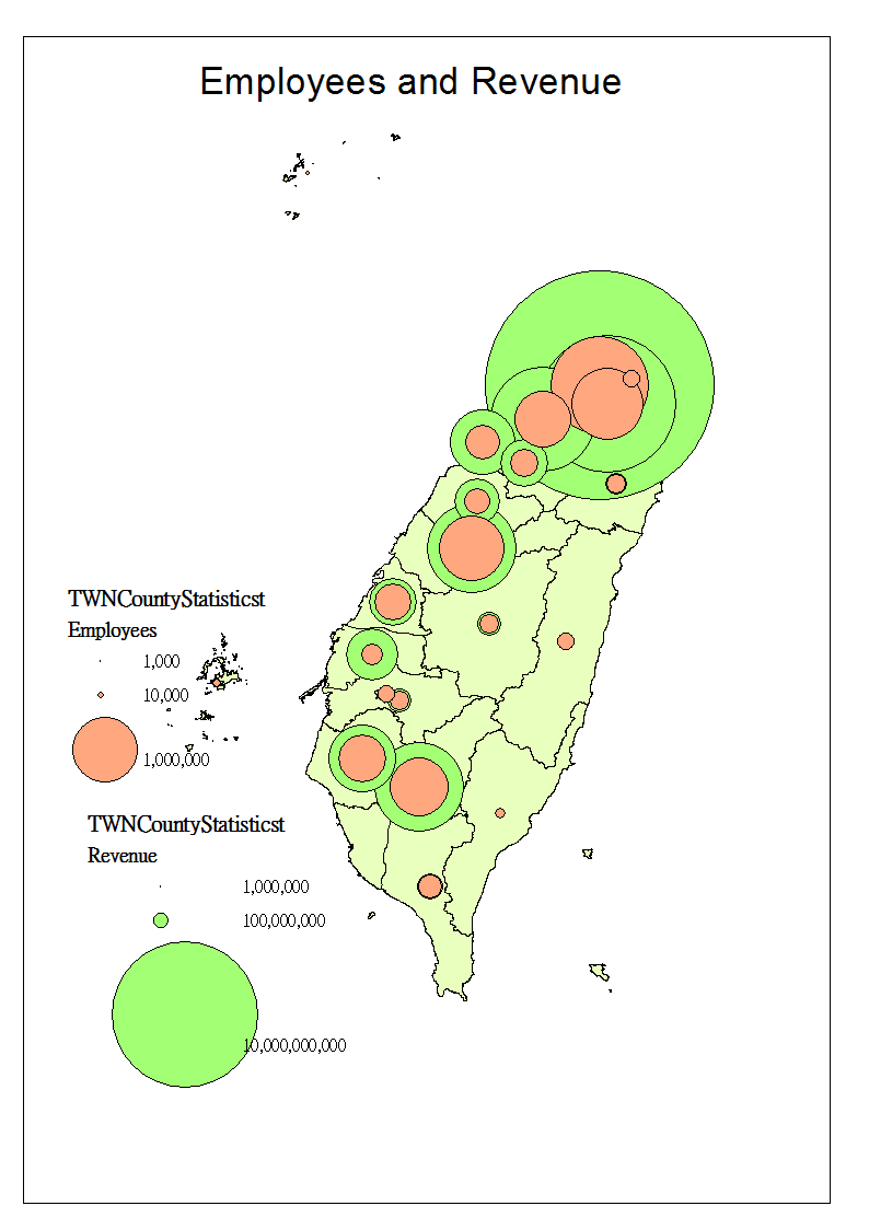
Economic Cluster Mapping of Taiwan Industries
台灣產業經濟聚落研究計畫
The cluster mapping methodology attempts to address economic and sustainable developmental questions: “Why are some nations or regions more prosperous than others? What conditions enable global corporations or local businesses to innovate and grow?” From Porter’s point of view that “Traditional economic theories fail to capture many of the underlying forces at work in today’s global economy. Competitiveness is the only way to achieve sustainable job growth, improve wages, and raise the standard of living—yet the real meaning of competitive advantage is poorly understood.”
此產業聚落研究方法試圖探討經濟與永續發展的問題:為什麼有些國家的經濟發展較其他國家發達?又有那些重要因素促使國際企業或是在地產業創新與成長?波特教授認為傳統的經濟理論已無法完全解釋今日全球經濟的多方因素角力,但競爭力是唯一一個對於就業率,薪資水平,與生活水準提升的重要因素,然而卻沒有太多人瞭解競爭優勢的真正意義。
Resources Management and GIS Volunteerism
資源管理與GIS使用者的貢獻
This research aims at integrating geospatial technologies to establish a core infrastructure system to support multidisciplinary digital humanities researches. The techniques used in the project include: Global Navigation Satellite System (GNSS), Geographic Information Systems (GIS), Digital Photogrammetry, Spatial Database Management System, dynamic mapping, and 3-D simulation, in order to facilitate storing, mapping, analysis, displaying of spatiotemporal information of digital humanities from various sources. This project will build a web-based GIS (WebGIS) system to serve as a platform for data sharing, which will allow all the members of the integrated project to share their data and research results. In addition, it can be used as an outreach tool to encourage community-based residents to participate in digital humanities researches. By integrating data of various sources, and using data mining techniques to analyze the database, we can produce new information from the database, which may allow the researches to extract more valuable spatiotemporal information from data of multiple sources.
此研究以整合地理空間科技為目標,以建立核心基礎系統來支持多領域數位人文研究。此計畫運用的技術包括: 全球衛星導航系統 (GNSS),地理資訊系統 (GIS),數位攝影測量 (Digital Photogrammetry),空間資料庫管理系統,動態地圖,3D模擬,以促進儲存,地圖標記,分析與展示多來源的數位人文時間空間資訊。
Religious Networks Mapping
宗教網絡地圖
This project plans to apply new research methods and tools of the Digital Humanities to the study of Chinese woodblock prints (nianhua 年畫), overcoming the limited scope of traditional methods, such as art history. By utilizing GIS spatio-temporal visualization and modeling analysis, this project will provide an overview perspective to study Chinese woodblock prints. In addition, this project will also facilitate Social Network Analysis (SNA) tools, such as UCINET and Gephi, to analyze the networks of sales and circulation, genealogy of craftsmen and workshops, and the regional variations of woodblock prints’ styles and functions. Both GIS and SNA tools can compensate the shortcomings of the traditional research methods. Nianhu, as a commodity and a medium of Chinese popular culture, is the window to reveal the mentalities of lay people, and Digital Humanities methods are applicable to the study of the social history economic history and material cultural history of the Chinese woodblock prints. We will establish a “linked open data” WebGIS platform to link the information of different professional collectors and databases, creating a sharing platform. This task can also crowdsource materials and local knowledge from online users, in order to interpret unrecognizable woodblock prints. Moreover, this WebGIS will collect not only traditional woodblock prints, but also preserve current prints for future studies, which can trace the transformation of nianhua in the earth 21st century.
本計畫克服傳統研究方式的限制,如藝術史,應用數位化人文研究新的方法與工具來探究中國木版年畫。利用GIS時空視覺化與模型分析,此計畫將提供年畫印刷的概論。此外,本計畫將促進社會網絡分析 (SNA) 工具 (如UCINET與Gephi軟體),來分析銷售與流通的空間分佈、年畫藝人與工作坊的網絡與譜系,與木版年畫的風格和功能的地域差異。作為商品與中國民間文化媒介,年畫是一扇顯示民眾心態史的視窗,而數位人文研究方法可應用於中國木版年畫的社會史、經濟史與物質文化史研究。我們將會建立一個「鏈結開放資料」的線上GIS(WebGIS)平台,以連結不同專業收藏家與資料庫的資訊,創立分享平台。此一任務亦可利用網路使用者提供的材料或在地知識,以解讀無法辨識的年畫版畫。此外,網路GIS不僅將蒐集傳統年畫,也為未來的研究保存當代使用的機器印刷年畫,紀錄21世紀初年畫使用的情形。
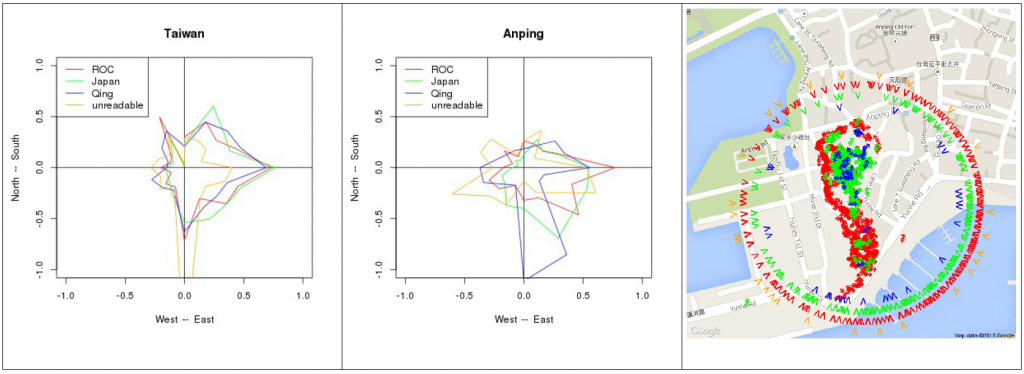
GIS Tombs Mapping of Taiwan and Region
本計畫目標是記錄與研究台澎金馬現存最古老的墓誌銘,及大陸鄉間和日本移民至台灣的地區的墓碑。除了200座紀錄完整的古墓,台灣可能還有數百座明代,數千座清朝與數萬座日治時期墳墓。這些古墳保存於台灣鄉間,藏於較新的社區墓地。平均而言,我們估計一處台灣鄉間社區墓地約有百分之一日治時期的墳墓,與千分之一清朝墳墓。
The project aims at documenting and researching the oldest tombstones that can still be found in Taiwan, Penghu, Jinmen, Mazu, plus related old tombs in Japan and rural sites in China, mainly in places from where migration to Taiwan started. In addition to 200 well-documented old tombs, Taiwan probably still has hundreds of Ming, thousands of Qing and tens of thousands of Japanese period tombs. In rural Taiwan, these old tombs have been preserved, hidden among more recent tombs in community gravesites. On average, we estimate that on a graveyard of a rural community in Taiwan, 1% of the tombs date from the Japanese period and 0.1% from Qing Dynasty.
各地墓地可能有高密度古墓,本研究處理的重要議題之一包括如何辨認墓地。對於大型墓地,我們會以無人空拍機與ArcheOS光度測定,以利GPS照相,創造3D模型。經由氣候,地理與文化特徵,我們研究這些模型所含的清代,日治與國早期墳墓的可能性。
One important question we tackle in this research is how to identify gravesites for each county which might have high density of old tombs. For larger gravesites, we will create 3D models through GPS-photography from a drone and subsequent photometry with ArcheOS. Onto these model we will project the respective probability of having Qing, Japanese period or early Republican tombs, based on the climatic, geographic and cultural features of that site.
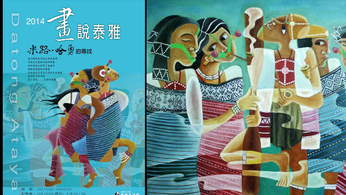
Taiwan Indigenous Innovation Arts
台灣原住民當代藝術國際推廣計畫
台灣原住民藝術文化是開展台灣未來國際認同的重要文化資產,本計畫的目的是為台灣原住民當代藝術創作留下一個較好的發展環境,藉由專業論述與專業規劃執行,建立台灣原住民當代藝術的自我主體,架構一套讓原住民當代藝術能成長茁壯的機制。